Archive Record
Images
Metadata
Object Name |
map |
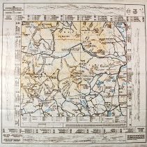
Caption |
Mt. Chocorua, 1989 |
Scope & Content |
Mt Chocorua. Map, adapted from Appalachian Mtn Club's Chocorua-Waterville Map, showing Mt Chocorua and the mountains (and their elevations) visible 360o from it's summit; roads, railroads, rivers, streams, lakes, ponds, mountains, hills, hiking trails. |
Area / Region |
Map of Mt. Chocorua Region, NH and Panorama from the Summit. |
Pub Date |
1989 |
Medium |
tyvek |
Condition |
good |
Number of images |
1 |
Publisher |
Chocorua Mountain Club |
Size |
18.5" x 19" |
Catalog Number |
2010.503.CL0067 |